Blog Posts

New Brunswick Update

New Brunswick Archaeology
Thanks to the Association of Professional Archaeologists of New Brunswick and their recent paper at the 2018 CAAs in Winnnipeg we now have New Brunswick data permit data from 2006-2016.
The APANB provided us with the raw data they received from the New Brunswick through a Right to Information and Protection of Privacy Act (RTIPPA) request in 2017. The APANB's paper addressed commercial archaeologists' response to increasing government participation in commercial practice, not just as regulators but as service delivery providers. The raw data raises interesting questions about any lines between government as regulator and government as consultant. It echoes some the earliest manifestations of CRM field work conducted directly by provincial archaeologists in Ontario, BC and elsewhere in the 1960s and 1970s.
In those days government archaeologists weren't directly competing with commercial archaeologists on anywhere near the scale they would be today. We hope the APANB and the New Brunswick government will share news of this developing model and relate effects on commercial practice and the regulatory regime in the province.

Satellite Outcome – The Findlay Maps
Reconnecting with the Findlay Maps
About Satellite Outcomes
If a project is listed on the Portal, we do our best to realize outcomes related to that project during our day-to-day. Sometimes, in chasing down one lead, we come across something significant enough that we just have to share it.
Peter Findlay and the University of Waterloo Geospatial Centre
In the 1970s, Peter Findlay was brought on by Ontario government archaeologist Bill Fox to transcribe the vegetation notes from log books of 19th century land surveyors onto county maps. Findlay also recorded notes about First Nations sites identified by the surveyors. Decades later, London archaeologist Shari Prowse together with the researchers from the University of Waterloo digitized many of these maps.
Learn more about the University of Waterloo Geospatial Centre
Access the Findlay Maps
Covering most of SW Ontario, the Findlay Maps are accessible from the University of Waterloo Geospatial Centre. Middlesex and Bruce Counties will also be added shortly after queries by the Research Portal to Shari Prowse.
About the Findlay Maps
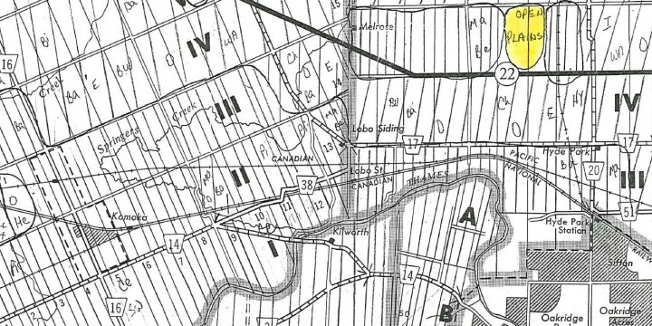
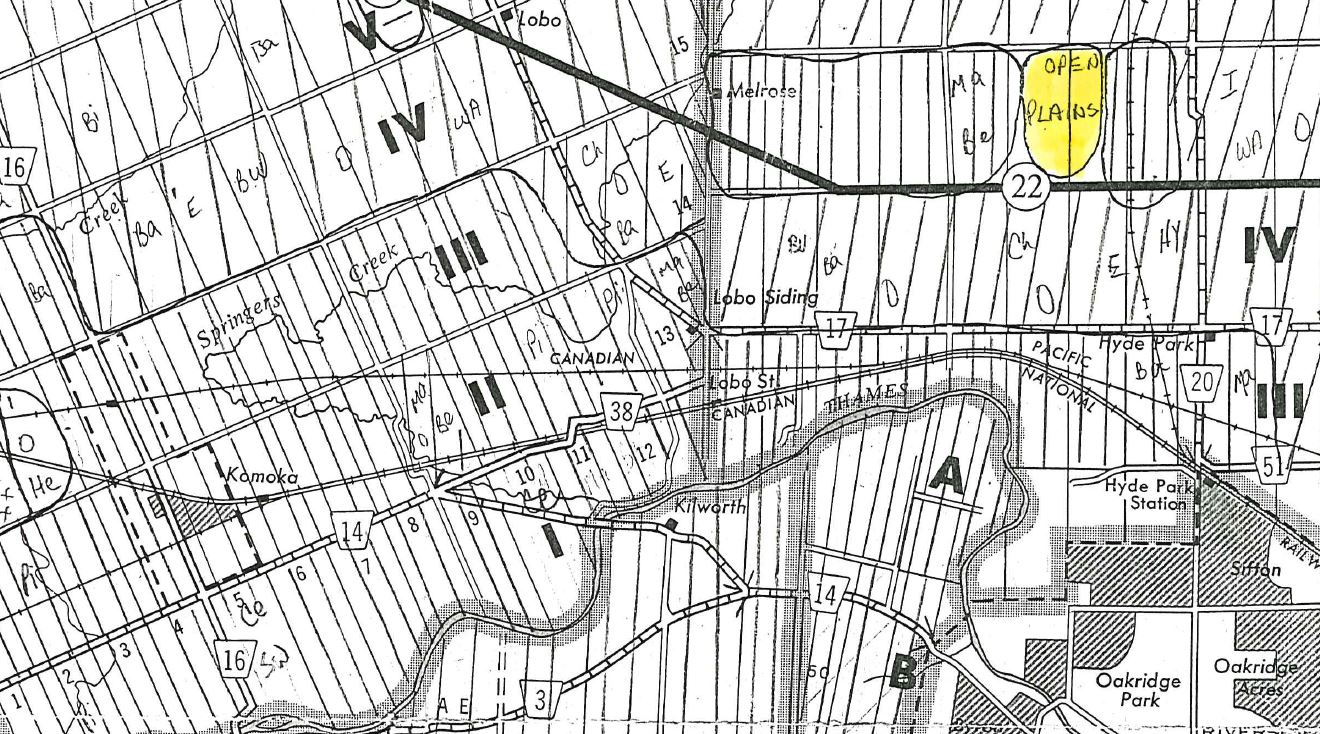
The Findlay Maps represent historical vegetation, soil and First Nations notations from 19th century land surveyor log books on county maps of southwestern Ontario. The maps identify swamps, dominant forest and stands of trees based on lot and concession. The London archaeologist who commissioned the maps, Bill Fox, was interesting in correlations between vegetation types and archaeological site potential.
About the Research Portal
A means to connect researchers and communities and to disseminate the results of their collaboration.
Have a Project?

And We’re Back

2018 CAAs and PEI and Alberta Data
Well we've been a bit tardy getting our first blog post out this year but it's not as if we've been slacking!
Some of you may have already noticed the CAA Programme Page growing in size. We have a few more uploads to make before we have almost all of the programmes available dating back to the 1970s. Big thanks to Joanne and Keith Braaten for acquiring and scanning these programmes and helping to create this invaluable resource.
Josh attended the 2018 CAAs in Winnipeg and talked about the Research Portal initiative. He was also able to connect with several of our provincial data contributors and put some faces to the names we contact annually. It's great to see provincial and territorial regulators at the CAAs and other archaeological conferences as they provide an important perspective to heritage management conversations.
Speaking of which, we are grateful to Alberta and PEI for providing 2017 permit numbers. The data has been updated and the pages have been converted to the new streamlined format.
We hope to have more data available in the coming months.

Project Outcome – Historic Lot and Concession GIS Layer
Heritage Planning, City of London - Historic Lot and Concession Layer
About the Community Organization
The City of London’s Heritage Planners support the conservation of London’s cultural heritage resources, including seven Heritage Conservation District, municipally-owned heritage properties, and archaeological resources in London, Ontario. The City of London provided in-kind support of this project in the form of staff time spent reviewing and implementing the new historic layer.
About the Researcher
John Moody is a doctoral candidate at Western University and the GIS Manager with Timmins Martelle Heritage Consultants Inc.
Media from the Project
Ontario Historic Lot and Concession GIS files are hosted by the Ontario government within Land Information Ontario.
"Land identifying a portion of a Concession within a Geographic Township. The townships, concessions and lots comprise the original township fabric of the Province."
About the Project
In 2017, during the Research Portal testing, Heritage Planners with the City of London identified their need to integrate historic lot and concession spatial information into their ArcGIS platform. The proposed project would digitally reconstruct the historic lots and concessions used to delineate property prior to the implementation of the municipal lot system. This system would streamline elements relating to historical research for property evaluations and designations under the Ontario Heritage Act. The Portal's network of academic and commercial contacts indicated that such information already existed, although its location was not well known.
John Moody, with Timmins Martelle Heritage Consultants Inc., knew where this information could be found and provided county-specific information to the Heritage Planners. GIS technicians with the City were then able to incorporate the data into a web platform for use by the Heritage Planners.
This project, such as it was a project, revealed the potential for the Portal to provide outcomes through an organization communicating a need and networking with researchers capable of quickly fulfilling that need.


About the Research Portal
A means to connect researchers and communities and to disseminate the results of their collaboration.
Have a Project?

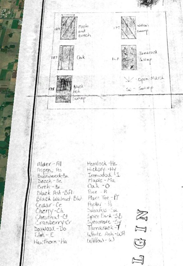
Almanac Update: Ontario 2016 and Updated Canadian Totals
The recent release of Ontario 2016 PIF numbers has allowed us to update our own information. We had also been waiting for Ontario’s numbers to release the Canadian totals (based on what we’ve gathered) for 2016.

Nova Scotia Data and the Canadian Archaeological Association Annual Meeting
Greetings!
Thanks to Sean Weseloh McKeane and Sam Bolton with Special Places, Nova Scotia we now have permit totals and permit types for the province from 2000-2016. Cheers!
For those of you attending the Canadian Archaeological Association Annual Meeting in Ottawa-Gatineau this week, the Almanac will be presenting its latest data, pitching the new site and talking about the road ahead. Come check us out Friday, May 13th at 10:00 am in Héritage B. Contributors Matt Beaudoin and Josh Dent are also presenting across the hall in Héritage A at 9:00 am and 9:40 am respectively the same day.
Hope to see you there!
2017 CAA Annual Meeting – Ottawa-Gatineau, Ontario – May 10-13, 2017
Programme

Almanac Update: Transfer Almost Complete!
Greetings!
We are happy to announce that the following regions’ data are now present in the new format:
- Alberta
- British Columbia
- Newfoundland and Labrador
- Northwest Territories
- Nova Scotia (Partial)
- Ontario
- Prince Edward Island
- Quebec (Partial)
- Saskatchewan
- Yukon
The remaining regions (Manitoba, New Brunswick and Nunavut) do not have sufficient data and will be held back until we can get access to this information.
New data includes Newfoundland and Labrador numbers and permit breakdown and 2016 numbers for many regions. We have also updated the total Canada permits numbers with the best available information up until 2015.
Many thanks to the assistance from the provincial and territorial governments!
The Almanac Team
Greetings from the Archaeologist’s Almanac’s New Home
Right now the site is a work in progress. If you’re looking for the original site you can find it here: http://almanarch.blogspot.ca/