Satellite Outcome – The Findlay Maps
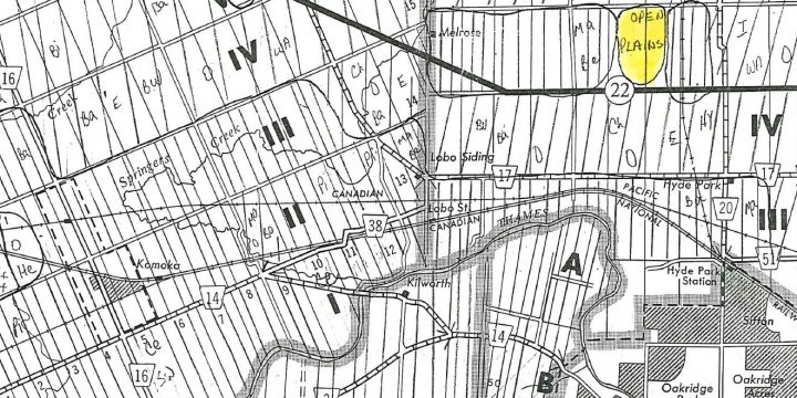
[siteorigin_widget class="SiteOrigin_Widget_Image_Widget"][/siteorigin_widget][siteorigin_widget class="SiteOrigin_Widget_Slider_Widget"][/siteorigin_widget][siteorigin_widget class="SiteOrigin_Widget_Headline_Widget"][/siteorigin_widget][siteorigin_widget class="SiteOrigin_Widget_Features_Widget"][/siteorigin_widget][siteorigin_widget class="SiteOrigin_Widget_Headline_Widget"][/siteorigin_widget] About the Findlay Maps The Findlay Maps represent historical vegetation, soil and First Nations notations from 19th century land surveyor log books on county maps of southwestern Ontario. The maps identify swamps, dominant forest and stands of trees based on lot and concession. The London archaeologist who commissioned the maps, Bill Fox, was interesting in correlations between vegetation types and archaeological site potential. [caption id="attachment_1229" align="aligncenter" width="586"] The Findlay Maps Legend[/caption] What made the notes so useful, was that 19th century surveyors recorded tree stands for a booming forest industry. Pine in particular, was in heavy demand in both British and American markets. Local governments used the surveyors' notes to support their lucrative timber licensing system (see works by J. David Wood for more…